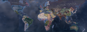
地图(map),大多数战术及战略决策都于其上进行制定。地图以直观的形式显示了为达目的所需的各类情报,如 天气, 空战, 陆战, 海战 和 建筑等的信息。
地图划分
|
|
这部分内容可能已不适合当前版本,最后更新于1.9。 |
地图划分有四种方式:
- 补给区域 是地图的次大划分单位。后勤和补给在这里进行计算。
地图模式
使用不同的地图模式时,地图上显示的信息不尽不同。要改变地图模式,可以点击主屏幕右下角的对应按键(图标)或使用相关快捷键。
默认地图模式
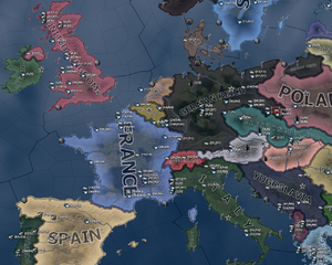
显示主权国家及军队。
在该模式下显示所有国家的名称及其政治色彩。地图拉远后,主要显示国家的颜色。地图放大时,地形逐渐变得清晰可见。使用这种方法可以将两种地图模式结合为一体。机场、海军基地、首都以及其他几乎任何地图上的物体都会在该模式下以不同的图标显示:
- 海军基地 为船锚。
- 机场 为飞机的俯视图。
- 首都 为星形。本国首都为 绿色 ,敌国首都为 红色 ,其它国家首都为灰色。
- 胜利点 以小点为符号,放大后可以看到其名称。胜利点价值越高,点的大小越大。它们的颜色与其首都相同。
- 军队 在地图上显示为兵牌及数量。
- 战斗 显示为一个指示器。当本国为优势时,其为 绿色 ,难分胜负时为 黄色 ,己方处境艰难时为 红色 。指示器上有一个数字,大小为一方对另一方优势程度的估计。
- 海战 与海军及其任务一起显示。
- 飞机 会在飞机运行的地方飞行。
- 要塞 及其它任何地区内、省份内建筑也都可见。
- 非军事区 周围会有一个 红色 轮廓,例如莱茵兰。
|
|
这部分内容可能已不适合当前版本,最后更新于1.9。 |
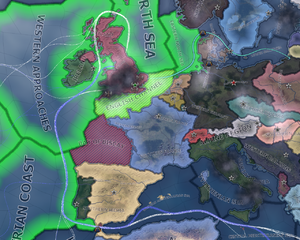
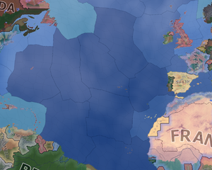
Shows strategic regions relevant to naval activity, with information on naval supremacy and naval tasks.
The naval map mode consists of the world's strategic regions, with a color scheme similar to the diplomacy for states on land under it. Convoy routes are also shown here with the following color scheme:
- Blue trade routes are resource transfers. These are imports, exports or resource transfers from owned oversea resources.
- White trade routes are supply transfers to oversea units.
- Green trade routes are lend lease routes.
Trade routes require convoys to operate.
Strategic regions that have sea provinces will be highlighted with green if they are under allied naval superiority. Provinces that are striped red are out of the fleets' operational range.
Straits
Canals or any type of controlled strait are shown on this map mode, and by hovering over them it is possible to see the access permissions your country has as well as the land provinces controlling the strait (blue outline). Straits are also shown on the Supply Map Mode and the Resource Map mode.
The following, are the names and province control points of the straits/canals on map and their respective permissions granted to nations (depending on the relations with the strait controllers).
| Name | Province Control | Unit Permissions | Contested? | Enemy | Friend | Neutral |
|---|---|---|---|---|---|---|
| Suez Canal | Cairo, Sinai | Armies | No | No | Yes | Yes |
| Navies | ||||||
| Submarines | ||||||
| Trade | ||||||
| Gibraltar Strait | Gibraltar, Spanish Africa | Armies | No | No | Yes | Yes |
| Navies | No | No | ||||
| Submarines | Yes | Yes | ||||
| Trade | No | No | ||||
| Bosphorus Strait | Istanbul | Armies | No | No | Yes | No |
| Navies | No | |||||
| Submarines | No | |||||
| Trade | Yes | |||||
| The Danish Belts | Sjaelland, Jutland | Armies | No | No | Yes | Yes |
| Navies | No | |||||
| Submarines | Yes | |||||
| Trade | No | |||||
| Kiel Canal | Schleswig-Holstein | Armies | No | No | Yes | No |
| Navies | No | |||||
| Submarines | No | |||||
| Trade | Yes | |||||
| The Panama Canal | Panama Canal (US occupied), Panama | Armies | No | No | Yes | No |
| Navies | No | |||||
| Submarines | No | |||||
| Trade | Yes |
Strategic air map mode
|
|
这部分内容可能已不适合当前版本,最后更新于1.9。 |
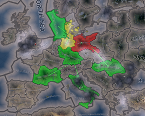
Shows strategic regions with information on aerial supremacy. It is automatically activated when an air base is selected.
The air map mode is, at first glance, merely a map of the strategic regions of the map. However, when at war, the regions can be highlighted with three colors:
- Red, which means the enemy has air superiority.
- Green, which means the nation or its allies has air superiority.
- Yellow, which means the air superiority is contested.
This map mode also shows all of the air missions currently set with the total number of planes assigned.
In the strategic air map mode ![]() more ground crews can be assigned, by clicking the icon in the desired strategic region. This gives a +10% bonus to mission efficiency in the strategic region.
more ground crews can be assigned, by clicking the icon in the desired strategic region. This gives a +10% bonus to mission efficiency in the strategic region.
补给区域地图模式
|
|
这部分内容可能已不适合当前版本,最后更新于1.8。 |
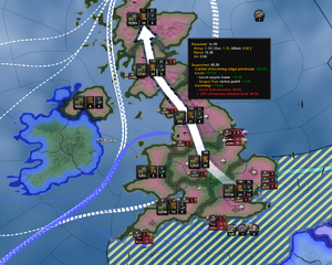
在补给区域地图上,展示了世界上的各个补给区域。就面积来说,一般补给区域比战区小,比单个省大。补给区往往由多个省组成。由国家及其盟友控制的补给区域中,驻扎了军队且没有超过可供应补给上限的会显示为绿色。补给区颜色为红色表示不能为该区域内所有军队提供补给。没有军队,也即不需要补给的地区没有颜色。此外,海岸与邻国的补给区显示为蓝色。该模式下显示海洋贸易路线,同海军战略地图一样。
每块补给区域都有一个桶和箱子组成的图标![]() ,旁边有一段铁轨
,旁边有一段铁轨![]() ,如果是临海且有海军基地的话,还会有一个船锚
,如果是临海且有海军基地的话,还会有一个船锚![]() 。每个图标旁都有相关的数字信息:
。每个图标旁都有相关的数字信息:
- 桶与箱子组成的图标
 上有一个数字,格式为0/114。第一个数字是友方军队和盟军使用的补给总量(数字为四舍五入的整数)。该总量为陆军、空军、海军所需补给的总和。第二个数字是补给上限。
 - 图标
 下方有一个数字,代表补给区域内所有地区的基础设施数量总和。
 图标可以被点击,每次点击都会在建造界面为该补给区域内所有地区添加一个基础设施建造序列,当然每个地区基础设施总数不能超过10个。如果补给区域内有任何地区在建设基础设施,数字都会变为黄色并显示为"x/y"格式,其中"x"为建设完成后基础设施总数,"y"为当前基础设施总数。
- 当鼠标在补给区域上方悬停时,
 图标上方会显示一个白色或红色的数字。该数字为此区域补给吞吐总量,大小为本区域平均基础设施水平的平方乘以2.5 (即为: (x/2)^2*10) 并向下取整(如果某个区域即接收又运出补给,那么该数字就意味着陆运补给的上限)。如果这个数字是变红色,就意味着该补给区域是一个瓶颈。此时就要提升该区域内的基础设施来加强补给运输能力。
 - 注意,当补给区域临海且补给来自海外时(也就是没有陆运可以提供补给的情况下),基础设施上方的数字是基础设施平均水平的平方乘以2 ( 即为: (x/2)^2*8)。
- 如果补给区域内有可用的海军基地
 ,该图标下会有一个数字用以表示该区域内海军基地的最高等级(与基础设施不同)。
- 点击
 图标会为该区域等级最高的海军基地添加一个升级序列。如果等级最高的海军基地已经有了一个升级序列,图标下的数字会变成黄色且格式为"x/y"。其中 "x" 为建设完成后的等级, "y" 为当前等级。
 - 当鼠标悬停在补给区域中时,
 图标上方也会出现一个白色或红色的数字。这个数字表明了可以通过该补给区域的海军基地接收或转运的补给总量,大小为补给区域内所有海军基地等级之和的三倍(这就是海运补给的计算方法,此时不考虑另一端海运容量的大小)。同基础设施上方的数字一样,当该图标上方的数字为 红 时表示当前补给区域为瓶颈,需要通过建设海军基地来提高补给吞吐量。
- 点击
- 注意,鼠标悬停在补给区域上方时,会有一个带箭头的标识显示从首都到目的地的补给链。补给链中每个补给区域的基础设施与海军基地图标上方的数字都会显示出来。红色数字表示其所在区域为当前整个补给链中的瓶颈。因此,当鼠标悬停时,只会有一条补给链,其上的基础设施和海军基地都有可能是瓶颈。如果基础设施和海军基地上方的数字都是白色,说明瓶颈不在此处,而是在供应链上的其它地方。
- 如果首都所在的补给区域成为瓶颈,说明该区域中的地区基础设施没有全部升级到10级。
关于以上数字的详细计算过程参见后勤页。
Terrain map mode
|
|
这部分内容可能已不适合当前版本,最后更新于1.9。 |
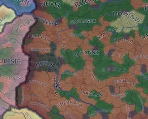
The terrain map mode shows the terrain of each region on the map using simplified colors. Land terrain has high adjusters for attack, defense and movement of land units. The terrain map mode can be useful to plan your offense or defense in for you favorable terrain.
Colors of the terrains:
- Plains: Brown
- Forest: Green
- Jungle: Green
- Marsh: Green/blue
- Hills: Light grayish with a bit yellow or green
- Mountain: Gray
- Urban: Dark Gray with road patterns
- Desert: Yellow
- Ocean: Blue
- Deep ocean: Dark blue
- Shallow sea: Light blue
- Fjords and archipelagos: Cyan
Resistance map mode
|
|
这部分内容可能已不适合当前版本,最后更新于1.9。 |
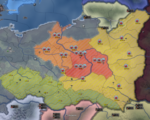
The resistance map mode shows resistance per state. Yellow indicates low, orange higher and red high resistance.
The percentage of resistance (0%-100%) is shown for each state. A green arrow downwards shows decreasing resistance, a red arrow upwards increasing resistance.
Also 3 resistance tiers are shown:
 Organized Resistance if the resistance is >25%
  Emboldened Resistance if the resistance is >50%
  Uprising if the resistance is >75%
Compliance map mode
|
|
这部分内容可能已不适合当前版本,最后更新于1.9。 |
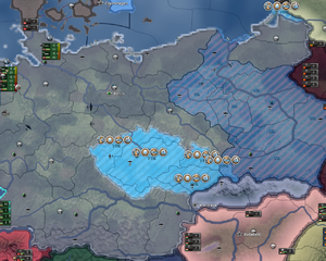
Shows compliance per state.
Lighter blue means more compliance.
The percentage of compliance (0%-100%) is shown for each state.
Also 5 compliance tiers are shown:
 Informants if the compliance is >15%
  Local Police Force if the compliance is >25%
  Reorganized Workforce if the compliance is >40%
  Volunteer Program if the compliance is >60%
  A New Regime if the compliance is >80%
Resource map mode
|
|
这部分内容可能已不适合当前版本,最后更新于1.9。 |
Shows resource locations and trade routes.
The resources map mode shows any convoy/ trade routes that are connected to the nation and canals/ straits across the world, similar to the naval map mode. However, this map mode looks like the default map mode when zoomed out, but when zoomed in, it shows a resource icon above any state that has a resource, along with the number of that resource produced in that province.
Diplomacy map mode
|
|
这部分内容可能已不适合当前版本,最后更新于1.9。 |
Shows diplomatic relations.
The diplomacy map mode shows its information through a multitude of colors.
- Green is the color that any land owned and controlled by the nation
- Light green is the color that any land occupied by the nation will be colored.
- Dark green is the color of any nation that has very good relations with the nation.
- Red is the color of any nations that the nation is currently at war with.
- Light red is the color of friendly territory that is occupied by enemies.
- Neon orange is the color of countries that the nation has wargoals against.
- Light orange is the color of any country the nation has very bad relations with.
- Blue is the color of any allied nations.
Factions map mode
|
|
这部分内容可能已不适合当前版本,最后更新于1.9。 |
The factions map mode shows the factions that exist around the world. The faction is colored the color of the leader nation, i.e. the Axis is grey due to the color of Germany, and it stretches across all nations in that faction.
States map mode
|
|
这部分内容可能已不适合当前版本,最后更新于1.9。 |
Shows states and population/ state category.
The states map mode shows an outline of every state in the world. These outlines are different colors based on the population of the state/ state category. This directly controls how many factories are allowed to be built in a state. The type of state can be found by simply hovering over it.
| 政策 | 意识形态 • 阵营 • 国策 • 内阁 • 政府 • 傀儡国 • 外交 • 全球紧张度 • 内战 • 占领区 • 情报机构 |
| 生产 | 贸易 • 生产 • 建设 • 装备 • 燃料 |
| 科研与科技 | 科研 • 步兵科技 • 辅助部队(支援连)科技 • 装甲车辆科技 • 火炮科技 • 陆军学说 • 海军科技 • 海军学说 • 空军科技 • 空军学说 • 工程学科技 • 工业科技 |
| 军事与战争 | 战争 • 陆军单位 • 陆战 • 编制设计 • Army planner • 集团军 • 指挥官 • 作战计划 • 战术 • 海军单位 • 海战 • 空军单位 • 空战 • 经验 • 损耗与事故 • 后勤 • 人力 • 核弹 |
| 地图 | 地图 • 省份 • 地形 • 气候 • 地区 |
| 事件与决议 | 事件 • 决议 |
hoi4de:Map hoi4es:Map hoi4fr:Map hoi4pl:Map hoi4pt:Map hoi4ru:Map


